 Most human activities leave a mark. In most cases this is intentional, but often it is not. Either way, with the right tools we can learn about what is happening now or what has happened in the past. This is an important element of many processes and certainly a crucial element of arms control and disarmament verification. To determine whether a state is complying with its obligations, its counterparts need to have information about various activities conducted by the state. One way to do so is to look at those marks and use them to make a judgment about current activities or, sometimes, about distant history.
Production of fissile materials for weapons is one of the areas where reconstructing the history of past activities is particularly important, since accurate accounting for fissile materials is a key element of nuclear disarmament and nuclear security. As it turns out, the physics of fissile material production makes such reconstruction possible. In a paper published in this journal in 1993, "Nuclear archaeology: Verifying declarations of fissile-material production," Steve Fetter suggested the amount of fissile materials that has been produced in a nuclear reactor could be determined by measuring isotope ratios in permanent components of the reactor core structure. This approach has been developed further and applied to a variety of processes and circumstances. In the first article of this issue, "Assessing Uncertainty in Plutonium Production Estimates Based on the Isotope Ratio Method," Benjamin Jung and Malte Göttsche suggest an approach to assess the accuracy of plutonium production estimates. While it has always been clear that detailed information about reactor design and operating history improves accuracy, the authors provide a way to quantify the relative importance of various factors and estimate the uncertainty in situations where this kind of information is not available.
As their case studies, Jung and Göttsche consider two types of reactors that can be used to produce plutonium--the heavy water-moderated CANDU and the graphite-moderated Yongbyon reactor. Their analysis shows that fuel burnup is the parameter that provides the largest contribution to the uncertainty. Uncertainties in nuclear cross-section data could be a significant source of inaccuracy as well. This work lays a basis for a more informed assessment of claims by the state operating the reactor about plutonium production that it provides to outside inspectors.
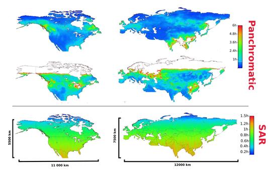
In the second article in the issue, "Capabilities of Commercial Satellite Earth Observation Systems and Applications for Nuclear Verification and Monitoring," Igor Moric examines a less cooperative approach to monitoring and verification. The number of earth observation satellites has grown dramatically in recent years, providing unprecedented coverage of almost the entire planet at various resolutions in multiple spectral bands. Synthetic aperture radar (SAR) satellites can see through the clouds and during night time. The growth of the number of companies that operate commercial earth observation satellites means that no state has a true monopoly over these capabilities.
Moric compiled a database of 300 currently operational satellite optical and radar systems offering panchromatic, multispectral, hyperspectral, infrared or SAR imagery to the public with a ground resolution of 5 meters or better. This dataset was then used to estimate the average revisit time for a range of areas using the SaVoir software package taking into account the capabilities of the sensors deployed on satellites as well as orbital parameters. The analysis, which includes simulations for China and DPRK, finds that it is now possible to image most of the Earth with a ground resolution under a meter at an average observation frequency of under 15 hours in the panchromatic and under 5 hours with SAR. The available sensor ground resolutions are sufficient to detect, identify and monitor most objects relevant for arms control and nuclear proliferation analysis.
Moric offers a cautionary note that the continued proliferation of satellite systems for Earth observation could fuel more unverified and incorrectly analyzed (and even fake) imagery that sways decision makers, with serious consequences for international security. He proposes efforts to ensure equal access to Earth observation satellite data for countries, agencies, NGOs, and individuals to allow independent review of sources, methods, and claims.
